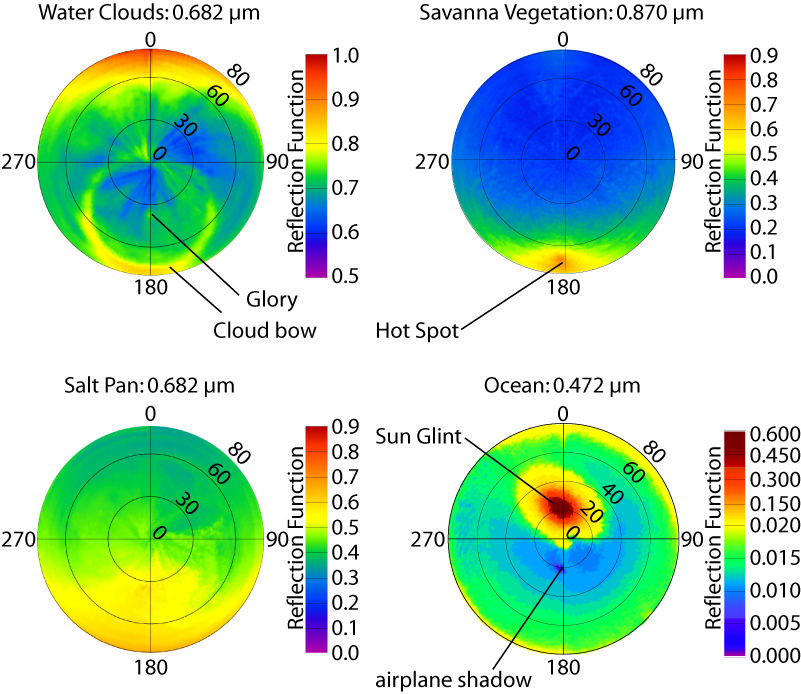
The images show BRDF from selected CAR channels obtained over marine stratocumulus cloud (water cloud) off the Skeleton coastline in Namibia (20.5°S, 13.1°E) in late winter conditions (September 13, 2000), over Skukuza (Savanna), South Africa (25.03° S, 31.51° E) on August 29, 2000, Etosha Pan (Salt Pan) in Namibia (19.0°S, 16.0°E) on September 16, 2000, and western Atlantic Ocean (Ocean) in the vicinity of Chesapeake Light (36.91°N, 75.71°W) on July 10, 2001.
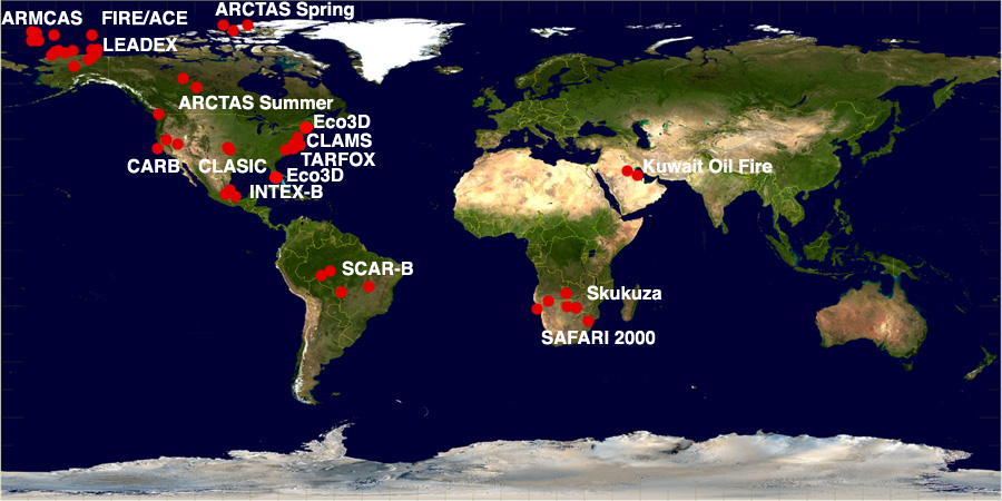
The Cloud Absorption Radiometer (CAR) flying aboard the University of Washington aircraft has provided a convenient and efficient means of obtaining complete bidirectional reflectance distribution function (BRDF) for many types of surfaces such as cloud, land surface, ocean surface, snow, tundra and salt pans at locations distributed all over the world as shown on the map marked by red dots.
To measure BRDF, the aircraft assumes a closed circular flight pattern over a uniform surface of interest. The pilot attempts to maintain a constant altitude near 2,000 feet over land and over water it can be as low as 600 feet with a constant aircraft speed and a roll angle of 20°. Unlike any ground based BRDF measuring instrument, which characterizes BRDF over an area no larger than tens of meters in diameter, CAR can survey the BRDF characteristics of a region on the order of kilometers in diameter.
The images above show the BRDF from selected CAR channels obtained over marine stratocumulus cloud (water cloud) off the Skeleton coastline in Namibia (20.5°S, 13.1°E) in late winter conditions (September 13, 2000), over Skukuza (Savanna), South Africa (25.03° S, 31.51° E) on August 29, 2000, Etosha Pan (Salt Pan) in Namibia (19.0°S, 16.0°E) on September 16, 2000, and western Atlantic Ocean (Ocean) in the vicinity of Chesapeake Light (36.91°N, 75.71°W) on July 10, 2001. In all polar plots, the viewing zenith angle is represented as the radial distance from the center, and azimuth as the length of arc on the respective zenith circle. The principal plane resides in the 0°-180° azimuthal plane with the sun located in the 180° azimuthal direction. With this definition, the upper half circle represents forward scattering and the lower half circle back scattering.
From the images, various light-scattering features can be observed. From the brdf of the water clouds, a glory at approximately 34° that coincides with the antisolar direction, and the cloud bow. The savanna brdf shows a pronounced peak (hotspot) at approximately 68° that coincides with the antisolar direction. The brdf over the salt pan is more enhanced in the backward relative to the forward scattering direction with no visible hotspot. The ocean brdf shows sunglint pattern in the forward direction and an aircraft shadow appears in the backscattering direction at 20° that coincides with the antisolar direction. More details can be found in Gatebe et al. (2003; 2005). It is interesting to see the radiance field above various surfaces in unprecedented detail because of the high resolution of the CAR measurements both angular (1 degree) and spatial (better than 4-10 m at nadir) coupled with high signal-to-noise ratio, and small quantization intervals (16 bits).
BRDF is needed in remote sensing for the correction of view and illumination angle effects (for example in image standardization and mosaicing), for deriving albedo, for land cover classification, for cloud detection, for atmospheric correction, and other applications. It gives the lower radiometric boundary condition for any radiative transfer problem in the atmosphere and is hence of relevance for climate modeling and energy budget investigations.
The CAR will continue to acquire such measurements on new platforms such as NASA P-3B, where it was integrated in 2008.