The CAR instrument can be used as a downward looking multispectral imager. In a downward imaging configuration, the CAR is rotated 90° around the aircraft's principal axis from it's usual starboard viewing position. The scan mirror scans 190° from the starboard horizon, past nadir, and then to the port side horizon. To acquire good quality earth view images and simplify geometric corrections for postflight image processing, the C-131A aircraft should maintain a straight flight track at a constant aircraft speed, constant altitude, zero pitch and roll angle, whenever possible.
The CAR imaging capability was first demonstrated on September 4, 1995 during a transit flight (flight number 1698) from Cuiaba to Porto Velho, Brazil.
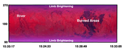
Figure 3. False color composite image of transit flight 1698, from Cuiaba to Porto Velho, Brazil on September 4, 1995. Red = 0.87 µm, green = 0.67 µm and blue = 0.47 µm.
Figure 3 is a segment of CAR quicklook image (0.87 µm) for that historical flight. The horizontal axis denotes the time code HH:MM in UTC and the vertical axis is the viewing angle, ranging from 90° at the starboard horizon to 270° at the port side horizon. The airplane travelled on average 25 m between the first and last scan pixel within a CAR active scan, and 48 m between two consecutive scans. To avoid oversampling at nadir, the aircraft's cruising altitude ideally should be below 2750 m. In the case shown, the average altitude is 4500 m, corresponding to a 80 m footprint at aircraft nadir.