2011-09-01 (Flight #2031) |
Aircraft Flight SummaryDate: 2011-09-01 |
Flight Track Map
Larger image (new window) Download KMZ/KML File (right click, save as) |
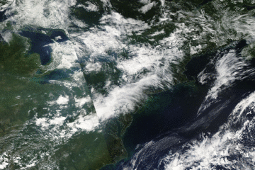
Satellite Image from MODIS
|
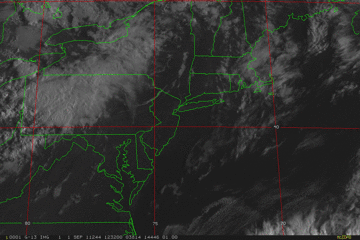
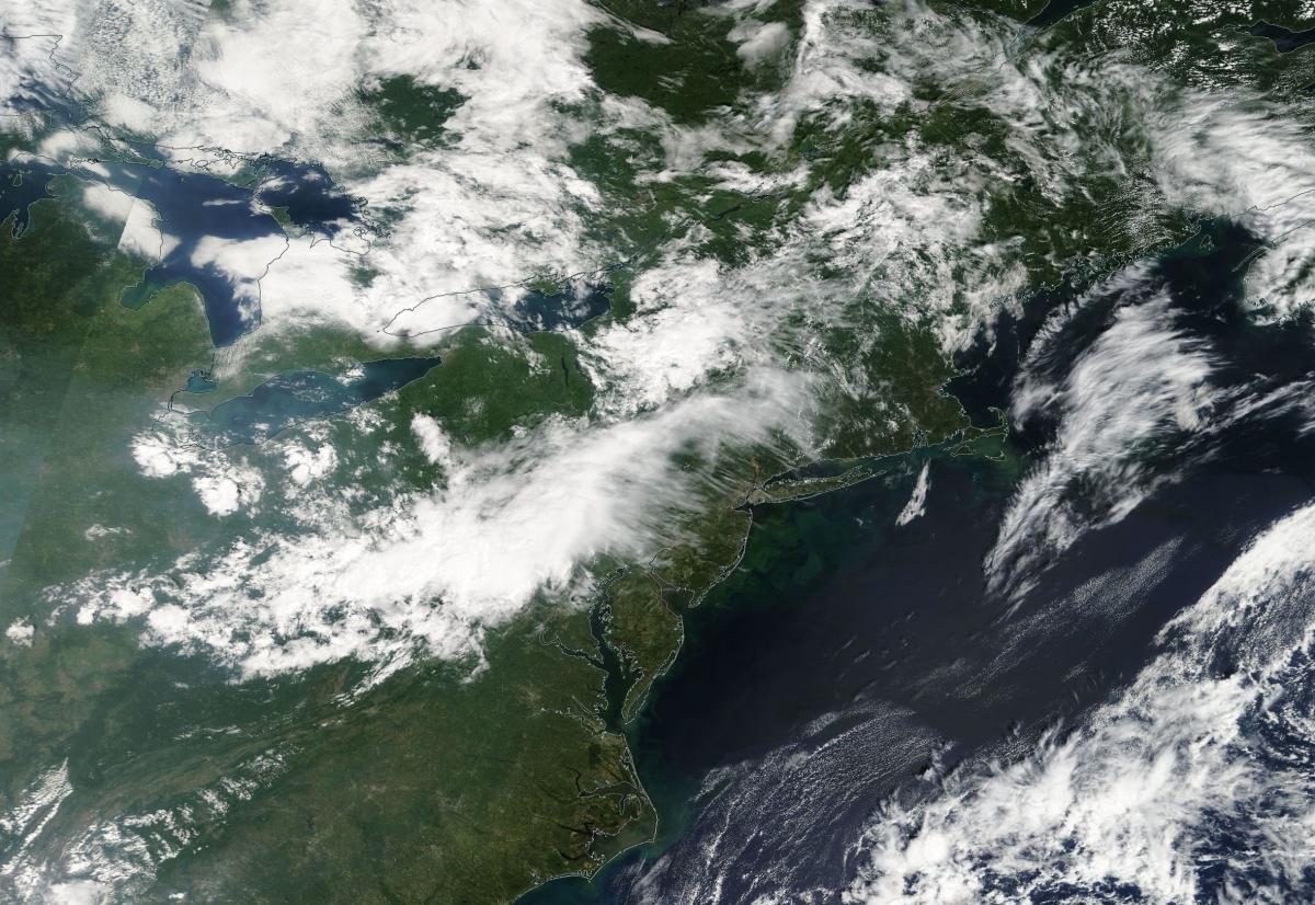
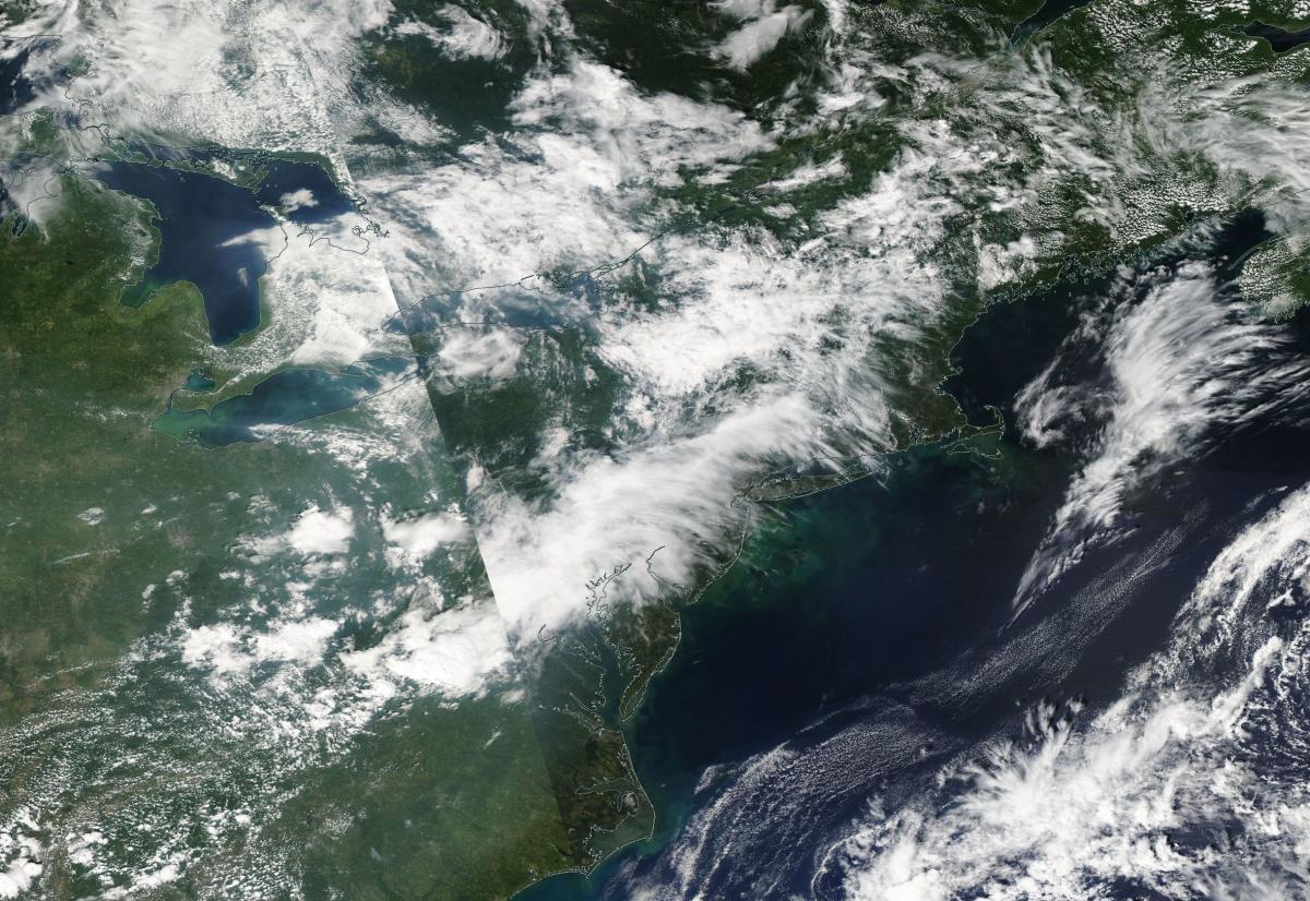
Satellite Images from GOES-13
|
CAR - (QuickLook)
Imagery from CAR Instrument
Click browse image thumbnail to load more detailed version (images open in a new window)
| Flight Direction | Flight Direction |
 |
 |
 |
 |
 |
 |
 |
 |
 |
Flight Mission Details
Overview:
This was the eighth flight. Flight was out of Bangor Airport, Maine to New Hampshire, back to Howland, Maine, then Quebeck, Canada and transit back to Wallops Flight Facility (WFF), Virginia (P-3B home base). Science goals include:
1. SIMPL/DBASR lines in New Hampshire, Howland, Maine and Quebeck, Canada.
2. Transit to Wallops.
P-3B Instrument Payload:
CAR - Cloud Absorption Radiometer measured angular distribution of scattered radiation and acquired BRDF measurements over SERC site near Wallops Flight Facility. Full operational the entire flight.
SIMPL: no instrument report, but was fully operational.
SIMPL is an innovative dual-wavelength, polarimetric, photon counting lidar that provides high-resolution information on the physical properties of terrestrial surfaces based on their light scattering signatures.
PDS Project Data System (PDS). No instrument report. Fully operational. Acquired base meteorological and navigational measurements.
DBSAR - No instrument report. Fully operational.
DBSAR: Digital Beamforming SAR (PI Rafael Rincon). DBSAR is a new generation airborne L- Band radar system that provides two- and three-dimensional fine-scale measurements of biomass.
Flight Path, Timing, and Measurements
Approximate time in UTC (US east coast time - 4 hours). Activities during CAR flight 2031 on September 1, 2011 out of Bangor Airport, to New Hampshire, back to Howland, Maine, then Quebeck, Canada and transit back to Wallops Flight Facility (WFF), Virginia. Observations by CAR operator/PI, Charles Gatebe.
12:20 - CAR not working. Mirror was not rotating. Through rial and error managed to fix the problem.
12:57 - engines on.
13:01 - take off.
13:12 - CAR power on.
13:15 - CAR door fully open.
13:16 - downward imaging. Widespread Ci; sky almost overcast.
13:24 - Power plant - near unrecognized city. Thin clouds below. Alt. 2630 m.
13:28 - thin Ci above and below P-3.
13:30 - starboard imaging.
13:31 - thin Ci signal obvious in the CAR data at a view angle of 60 deg.
13:36 - nice cloud below, but thin Ci above.
13:39 - DBSAR lines. Cloud deck below and above P-3.
13:45 - developing Cu.
13:49 - DBSAR line 2. Clear sky above, clouds below P-3l Alt. 2630 m.
13:59 - DBSAR line 1 offset.
14:05 - SIMPL detecting two cloud layers at different alt.
14:09 - still in DBSAR offset.
14:18 - downward imaging mode.
14:22 - Ci above, Cu below P-3.
14:23 - clear sky above, Cu below P-3. Count is 7000. Cloud bow observed over Cu - shows presence of water.
14:31 - starboard imaging. Thin Ci above P-3.
14:36 - developing Cu; nice cloud sides measurements. Very strong signal at 0.34 µm.
14:40 - end of measurements at the New Hampshire site. Heading back to Maine for measurements over Howland forest.
14:42 - thin clouds below and above P-3.
14:46 - Ch 3 (0.47 µm) saturating close to the sun.
14:53 - Bangor airport.
15:02 - doing SIMPL lines.
15:05 - SIMPL lines. Ci above and scattered Cu below P-3. Ci signal shows up in the data.
15:16 - mining quarry.
15:18 - a line Ci above P-3.
15:23 - end of SIMPL lines. Will head to Quebec, Canada.
15:26 - scattered Cu below and widespread Ci above P-3. Alt. 3056 m.
15:32 - thick clouds above, scattered Cu below.
15:42 - Alt. 4986 m.
15:48 - downward imaging. Sky completely overcast. Few Cu below.
15:50 - Lake below P-3. Sun barely visible through the clouds.
15:52 - Lake below P-3.
15:53 - small islands; flooded plane visible.
16:01 - lots of clouds above. Scattered Cu below. Alt. 4983 m.
16:02 - thin clouds and strong winds below P-3.
16:05 - DBSAR lines.
16:07 - starboard imaging. Lots of clouds above P-3; scattered Cu below.
16:12 - many small lakes. Very rugged terrain.
16:15 - problems with CANS roll data.
16:20 - many open water ponds and streams.
16:24 - DBSAR lines. Ci above and scattered Cu below P-3.
16:37 - completely overcast.
16:51 - descending to lower altitude in a spiral.
16:55 - skimming the top of clouds.
16:57 - Cut through a cloud. Flying at 2000 m.
16:59 - Alt. 2593 m. Multilayer clouds.
17: 01 - beautiful scenes.
17:02 - SIMPL targets.
17:04 - deep canyon.
17:05 - end of SIMPL lines.
17:13 - small town. SIMPL target.
17:14 - quarry mines.
17:17 - thin Ci above; scattered Cu below P-3.
17:22 - SIMPL line start. Lots of Cu below P-3, Ci above.
17:28 - en of SIMPL lines.
17:30 - climbing to a higher level for DBSAR lines. Waiting for clearance from airtraffic controllers.
17:36 - SIMPL lines repeat while waiting for clearance to climb to higher levels.
17:45 - Ci breaking up.
17:46 - climbing to a higher level.
17:50 - condensation (CAR) > 450%. Alt. 3000 m.
17:53 - Condensation (CAR) < 1005. Alt. 5134 m. Thin Ci seen above P-3.
17:57 - misty.
17:59 - roll and pitch < 1 deg.
18:01 - misty. Condensation >300%. Over a river.
18:05 - Condensation <90%.
18:21 - thick Ci above P-3. Alt. 5143 m.
18:26 - went through Ci. Alt. 6000 m.
18:28 - end of science data collection; heading home to Wallops. Alt. 6929 m.
18:34 - big river.
18:36 - thin Ci above. Alt. 6954 m. Cu below P-3.
18:42 - very clear sky above. Thick clouds below the P-3.
18:44 - good measurements of cloud sides.
18:46 - tall Cb (anvil shape).
18:49 - still in Canada. Clear sky above, clouds below.
18:53 - nice multilayer clouds; developing Cbs.
18:57 - entering USA.
19:01 - very bright looking down.
19:06 - homogeneous clouds below. Thin Ci above.
19:08 - Ch 2 (0.38 µm) flat top to bottom between two cloud layers.
19:11 - diffusion domain-like conditions. Alt. 6977 m.
19:15 - out of the diffusion domain region. Thin clouds above, but thick clouds below.
19:18 - CANS temp reading: -3.9 deg C.
19:20 - diffusion domain conditions.
19:23 - clear sky above, cloudy below.
19:26 - water (river) glint seen.
19:28 - Cb developing. Big river.
19:30 - Cu developing over the river. Clear sky above.
19:36 - extensive flooding due to hurricane Irene.
19:38 - inside a thin cloud - sun and the surface visible.
19:41 - New York city.
19:43 - Airports visible.
19:47 - inside a thin cloud - ground visible.
19:48 - near diffusion domain.
19:50 - inside cloud - ground visible.
19:58 - more clouds above than below P-3.
19:59 - near diffusion domain.
20:02- near diffusion domain, but ground visible in some sections.
20:03 - descent.
20:06 - two bigs ships; ship wake visible.
20:10 - SIMPL roll maneuver (+/- 5 deg. Pitch +/- 5 deg).
20:11 - roll maneuver set up.
20:19 - pitch maneuver.
20:21 - CAR door closed. CAR packed.
20:22 - CAR power off.
20:26 - landed.
20:30 - stop taxing/engines off. CANS power off.