2011-09-13 (Flight #2033) |
Aircraft Flight SummaryDate: 2011-09-13 |
Flight Track Map
Larger image (new window) Download KMZ/KML File (right click, save as) |
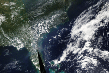
Satellite Image from MODIS
|
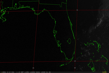
Satellite Images from GOES-13
|
CAR - (QuickLook)
Imagery from CAR Instrument
Click browse image thumbnail to load more detailed version (images open in a new window)
| Flight Direction | Flight Direction |
 |
 |
 |
 |
 |
 |
 |
 |
Flight Mission Details
Overview:
This was the tenth flight, out of Homestead Air Force Base, Florida. Science goals include:
1. SIMPL/DBASR lines over the Everglades, Florida.
2. CAR cloud measurements
P-3B Instrument Payload:
CAR - Cloud Absorption Radiometer measured angular distribution of scattered radiation and acquired BRDF measurements over the Everglades. Full operational the entire flight.
SIMPL: no instrument report, but was fully operational. Dave Harding, Phil Dabney operated the instrument.
SIMPL is an innovative dual-wavelength, polarimetric, photon counting lidar that provides high-resolution information on the physical properties of terrestrial surfaces based on their light scattering signatures.
PDS Project Data System (PDS). No instrument report. Fully operational. Acquired base meteorological and navigational measurements.
DBSAR - No instrument report. Fully operational.
DBSAR: Digital Beamforming SAR (PI Rafael Rincon). DBSAR is a new generation airborne L- Band radar system that provides two- and three-dimensional fine-scale measurements of biomass.
Flight Path, Timing, and Measurements
Approximate time in UTC (US east coast time - 4 hours). Activities during CAR flight 2033 on September 13, 2011 out of Homestead Airforce base, Florida. Observations by CAR operator, Rajesh Poudyal.
11:03 - motor/nav/computer turned on.
11:56 - take off.
12:00 - data start.
12:04 - very low cloud below.
12:06 - fw looks ok, on ch 4 (2.1 µm).
12:11 - DBSAR line in position, imaging mode, stop active roll.
12:12 - above mangrove forest, very low level cloud.
12:13 - DBSAR data line.
12:18 - end data line.
12:28 - noticed CAR data drop.
12:30 - on DBSAR lines.
12:38 - end of data line.
12:50 - starboard mode, take cloud measurement over ocean.
12:53 - probable BRDF circle?? (may be incomplete).
12:57 - imaging mode, repeat of DBSAR line 2, stop active roll correction.
13:06 - BRDF??
13:07 - anti-solar point?
13:09 - imaging mode, DBSAR line 3.
13:15 - starboard mode.
13:22 - data line, on imaging mode.
13:34 - data line 5.
13:38 - starboard mode, cumulous clouds below. On DBSAR line
14:10 - repeat line 4.
14:15 - end repeat 4.
14:32 - offset line 6 for DBSAR, cloud measurement for CAR and SIMPL. Imaging mode no roll correction.
14:42 - starboard mode
14:56 - ship on sun glint
15:00 - fw to 2.2 µm was at 2.1 µm, SIMPL continued taking cloud data until 15:05 UTC.
15:12 - over ocean.
15:26 - going to 8k altitude, changing to imaging.
15:30 - starboard mode to measure some cloud in horizon.
15:36 - Florida keys.
15:40 - ship from 8k altitude.
15:46 - DBSAR line 4. Imaging mode.
15:51 - end of line 4.
16:15 - DBSAR lines at 8k.
16:26 - decent from 25k ft to 17.5k ft.
16:37 - imaging mode, greenish everglade coastal water (check UV channels).
16:39 - starboard mode.
16:40 - big cloud profile (pic).
16:46 - imaging mode.
17:08 - starboard mode, Cloud reflection.
17:16 - imaging mode.
17:32 - clipping cloud, diffusion domain??
17:58 - scanning sky.
18:00 - door close.
18:09 - landed.