2011-09-16 (Flight #2035) |
Aircraft Flight SummaryDate: 2011-09-16 |
Flight Track Map
Larger image (new window) Download KMZ/KML File (right click, save as) |
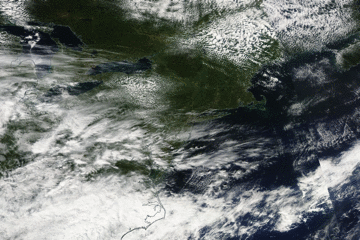
Satellite Image from MODIS
|
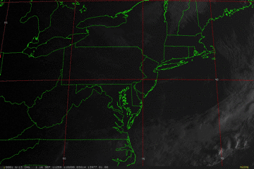
Satellite Images from GOES-13
|
CAR - (QuickLook)
Imagery from CAR Instrument
Click browse image thumbnail to load more detailed version (images open in a new window)
| Flight Direction | Flight Direction |
 |
 |
 |
 |
 |
 |
 |
 |
 |
 |
Flight Mission Details
Overview:
This was the twelfth flight out of Wallops Flight Facility (WFF), Virginia (P-3B home base). Science goals include:
SIMPL and DBSAR lines over PA, NH, and ME along with lines over the local WFF area. Time 7.7 hours.
P-3B Instrument Payload:
CAR - Cloud Absorption Radiometer measured angular distribution of scattered radiation and acquired BRDF measurements during the entire flight.
SIMPL: no instrument report, but was fully operational. Phil Dabney operated the instrument.
SIMPL is an innovative dual-wavelength, polarimetric, photon counting lidar that provides high-resolution information on the physical properties of terrestrial surfaces based on their light scattering signatures.
PDS Project Data System (PDS) measured base meteorological and navigational measurements. Fully operational.
DBSAR - No instrument report.
DBSAR: Digital Beamforming SAR (PI Rafael Rincon). DBSAR is a new generation airborne L- Band radar system that provides two- and three-dimensional fine-scale measurements of biomass.
Summary of the flight (Gatebe, 19 September 2011):
In deed, our decision to go North paid handsomely. We found very good weather for CAR/SIMPL measurements both in Massachusetts and New Hamphshire. Many thanks to Dave for making the call at yesterday telecon (18 Sep. 2011).
We had no instrument issues and we got a tour of many states: Virginia, Maryland, Delaware, New Jersey, Massachusetts, New Hampshire, Vermont, New York, and Pennsylvania.
We took a lot of pictures, e.g. at Harvard Forest site, showing two Eddy Flux Towers. We managed to take measurements over both towers.
Our instruments will be deinstalled tomorrow (20 September 2011) and the hard work of analyzing data will begin after performing post-flight calibration.Thanks for the great team work
Flight Path, Timing, and Measurements
Approximate time in UTC (US east coast time - 4 hours). Activities during CAR flight 2035 on September 16, 2011 out of Wallops Flight Facility in Virginia heading to Pennsylvania, Hew Hampshire and Maine. Observations by CAR operator/PI, Charles Gatebe.
11:30 - physical inspection of the CAR; found ok.
11:35 - instrument power check. Door not opening automatically. Opened manually.
12:09 - aircraft engines on.
12:13 - taxing.
12:17 - take off. Mostly clear sky, but some thin cirrus clouds.
12:20 - instrument powered on; working nominally.
12:31 - filter wheel channel at 2.1 µm; looked stable.
12:32 - thin cirrus above.
12:37 - Ch 3 (0.47 µm) show an increase, while the other channels show a decrease. Cirrus still visible.
12:40 - over a river.
12:41 - took a picture of a bridge. Alt. 4450 m.
12:49 - generally clear, but thin cirrus above. Land cover looked pretty much the same.
13:04 - roll reading -ve (left bank), while the aircraft is banking to the right.
13:13 - DBSAR lines in Pennsylvania over the boulder fields.
13:22 - looked hazy. Cirrus deck out towards the horizon. P3 in a clear slot (no clouds above or below).
13:29 - heading to a minefield; airport below P-3.
13:32 - developing Cu; increasing Ci.
13;35 - End of DBSAR lines at 5048 m. Descended to a lower level for SIMPL lines.
13:38 - filter wheel at 1.6 µm; a little noisy.
13:44 - SIMPL line 1.
13:46 - took a picture.
13:47 - scattered Cu below P-3; thin & widespread Ci.
13:55 - more Cu below P-3.
14:01 - filter wheel noisy.
14:06 - SIMPL line #2.
14:10 - end of measurements over the PA sites. Headed North to Maine.
14:29 - filter wheel stable.
14:30 - very clear sky above. CAR scanning the surface from horizon to horizon.
14:37 - filter wheel unstable/noisy. Clear sky above and scattered Cu below.
14:40 - cryopump turned off.
14:43 - cryopump turned on.
14:45 - glint over the lakes.
14:47 - scattered Cu below P-3; clear sky above. Filter wheel unstable/noisy.
14:50 - filter wheel stabilizing.
14:52 - filter wheel stable. Clear sky above P-3, scattered Cu below.
14:56 - more clouds below P-3.
15:00 - Bartlett site. Dense clouds below P-3, very clear above, Alt. 2523 m. SIMPL lines setup.
15:07 - skimmed optically thick clouds, but broken.
15:20 - CAR in starboard imaging. P-3 circling in a field of broken clouds. Headed to Howland, Maine. Clear sky above.
15:30 - clear sky above P-3, scattered below. Alt. 4078 m.
15:39 - glint reflection from cloud; rainbow observed.
15:41 - over a big river.
15:43 - picture of a city/next to a river.
15:45 - P-3 banked to the left (-ve), but CANS roll data reading +ve. Something was wrong with the system.
15:47 - DBSAR lines over Howland. Broken clouds. CAR in the downward imaging mode.
15:51 - missing scans. P-3 was flying straight and level, but wondered what was happening with the CAR.
15:58 - glint reflection over clouds (count 21917).
16:01 - very clear sky above clouds.
16:05 - DBSAR lines at Howland. Broken clouds below P-3, but clear sky above.
16:21 - broken clouds below P-3 and clear sky above.
16:30 - ended DBSAR line #2.
16:37 - beginning of DBSAR line #3. Very clear sky above P-3, broken clouds below. Alt. 4365 m.
16:43 - filter wheel at 2.2 µm.
16:44 - over Bangor city.
16:45 - end of DBSAR line #3.
17:02 - setting up for DBSAR line #3.
17:08 - filter wheel at 2.3 µm.
17:13 - clear sky above, broken clouds below.
17:16 - filter wheel at 1:55 µm.
17:19 - imaging mode while P-3 was making right turns.
17:24 - filter wheel at 1.6 µm.
17:26 - filter wheel at 1.7 µm.
17:33 - filter wheel at 2.1 µm.
17:51 - end of DBSAR lines. Clear sky above during the DBSAR lines.
17:58 - ascending; alt. 6721 m.
18:00 - filter wheel at 2.3 µm.
18:06 - filter wheel at 2.3 µm; looked very dark over water.
18:09 - ships in the area. Clear sky above, scattered Cu below. Flight level - 6771 m.
18:17 - clear sky above (alt. 6807 m), scattered Cu below.
18:20 - over car parking lot.
18:23 - hazy, saw a layer toward the horizon.
18:27 - becoming more hazy.
18:33 - mine dump; still hazy; some Ci towards the horizon.
18:35 - Alt. 6879 m. Ratio between different channels constant (80 deg.).
18:42 - Ci above, clear sky below; still hazy towards the horizon.
18:47 - flooded river inlet. Ship wake noted.
18:48 - thick Ci above; alt. 6895 m.
18:50 - crossing the bay. Lots of Ci above.
18:52 - v-shaped airport runways. Filter wheel very noisy.
18:57 - Filter wheel very noisy. Widespread Ci.
19:00 - Cryopump turned off.
19:04 - thin clouds. Cryopump turned on.
19:09 - filter wheel channel stabilizing. P-3 in a misty environment; Ci above breaking up.
19:10 - Filter wheel stabilizing.
19:14 - flooded coastline from hurricane Irene. Lots of Ci above.
19:17 - Atlantic city.
19:19 - descent. Alt. 5084 m.
19:25 - Delaware coastline. Overcast above, no clouds below.
19:26 - Separation of dark/green water.
19:29 - Delaware coastline. Lots of Ci above. Alt. 1972 m.
19:34 - Calibration lines for SIMPL. Assateague Islands.
19:40 - SIMPL lines near Wallops.
19:44 - CAR door closed.
19:45 - CAR power off.
19:49 - landed.
19:51 - CANS powered off.
19:54 - stopped taxing.
19:55 - engines off.