1995-09-05 (Flight #1700) |
Aircraft Flight SummaryDate: 1995-09-05 |
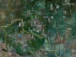
Flight Track Map
Larger image (new window) Download KMZ/KML File (right click, save as) |
Satellite ImageImage Unavailable MODIS/Aqua larger image (afternoon) - unavailable |
Satellite ImagesImage Unavailble |
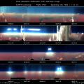
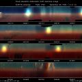
CAR - (QuickLook)
Imagery from CAR Instrument
Click browse image thumbnail to load more detailed version (images open in a new window)
| Flight Direction | Flight Direction |
|
|
|

|

|
Flight Mission Details
It was an uneventful day; flew in thick smoke layer.
Flight Path, Timing, and Measurements
18:57:15 UTC, scan count = 700: going South-East of Porto Velho. Altitude around 5200 feet and climbing through a thick smoke layer. IR detector temperature is -187 °K, still too hot for 2.29 µ, the rest of filterwheel channels appear to be O.K.
19:05:01 UTC, scan count = 1437: C131A is at 9500 feet, approaching the top of the thick smoke layer. The ground is not visible. CNC1 = 1500 /cc. Many cumulous clouds are embedded in the smoke layer. Some of them are on the starboard side of the plane right now. IR detector temperature is -195 °K.
19:17:58 UTC, scan count = 2742: going through a big cumulous cloud right now at altitude of 13500 feet. The top of the smoke layer is about 13000 feet, so we are just above the top at this point in time.
19:26:02 UTC, scan count = 3557: over the sun photometer site at 13500 feet. A thin layer of wispy clouds is visible and is about 1000 - 2000 feet above the lower smoke layer. CNC1 = 440 /cc. It does not look good for CAR BRDF study over the smoke layer. To many cumulous cloud tops present in the vicinity.
19:40:20 UTC, scan count = 4495: descending into the smoke layer in circular pattern. CNC1 == 1160 /cc and the altitude is 11010 feet. IR detector temperature is -202 °K.
20:11:15 UTC, scan count = 8110: lowest flight level for today 1500 - 1900 feet. Quite haze there and we are just over the forest.
20:21:34 UTC, scan count = 9149: flying at low level over a swamp.
20:22:53 UTC, scan count = 9282: climbing through the smoke layer and heading back to the Porto Velho airport. It is a short flight.
20:33:58 UTC, scan count = 10400: ready to close the CAR door.
