Flight Time: 20:58 UTC -01:19 UTC
Data Time: 21:00 UTC -00:57 UTC
Aircraft Type: NRL P-3
Flight Scientist: Dr. Charles K. Gatebe
Flight Number: 2063
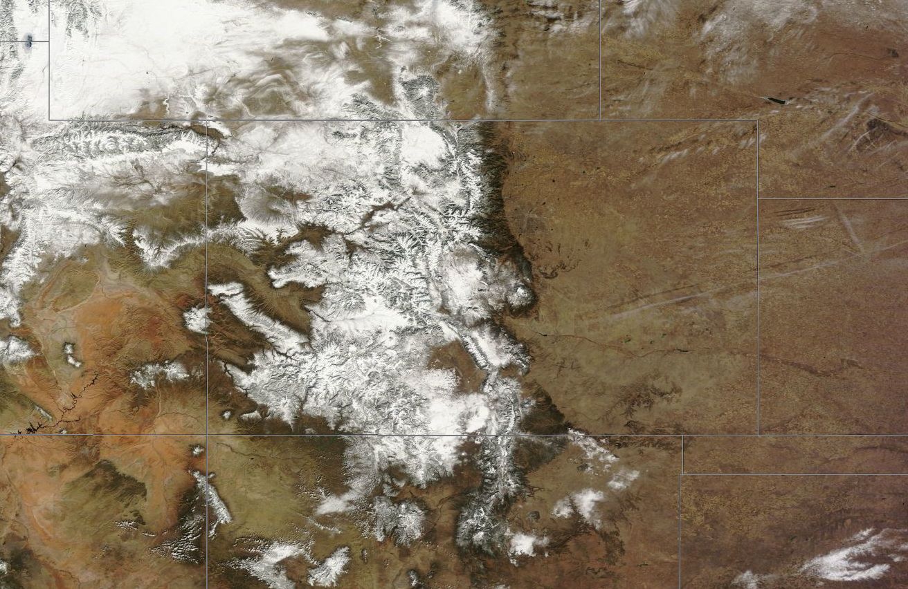
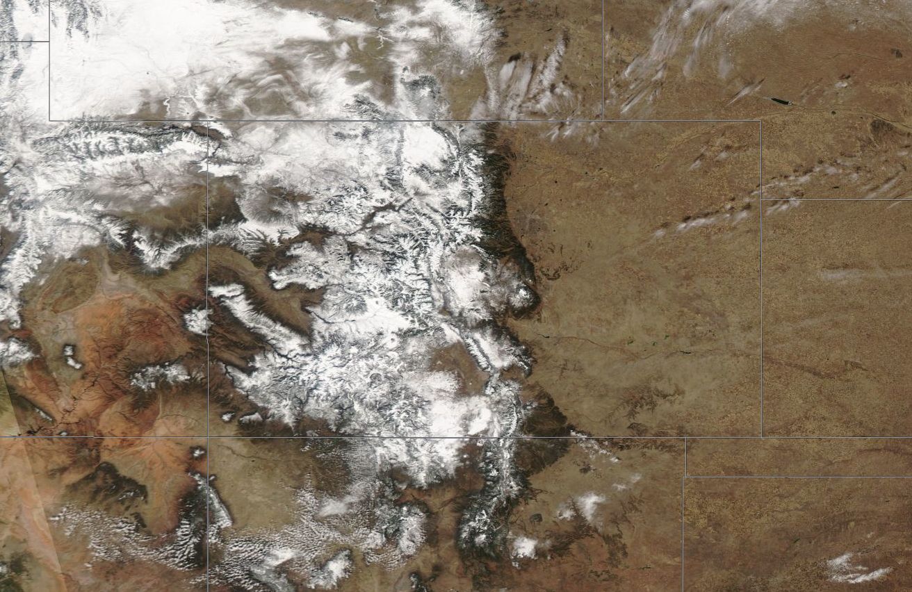
Mission Location: Colorado Springs, CO.
Lat/Lon Coverage: 40.2003° N 37.6731°S -104.561°E -108.410°W
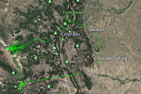
This was the first Navy Research Laboratory (NRL) P-3B flight out of Peterson Air Force Base (AFB), Colorado Springs (KCOS), Colorado. The aircraft took measurements over Grand Mesa and Senator Beck under low sun and clear sky conditions. Key instruments include:
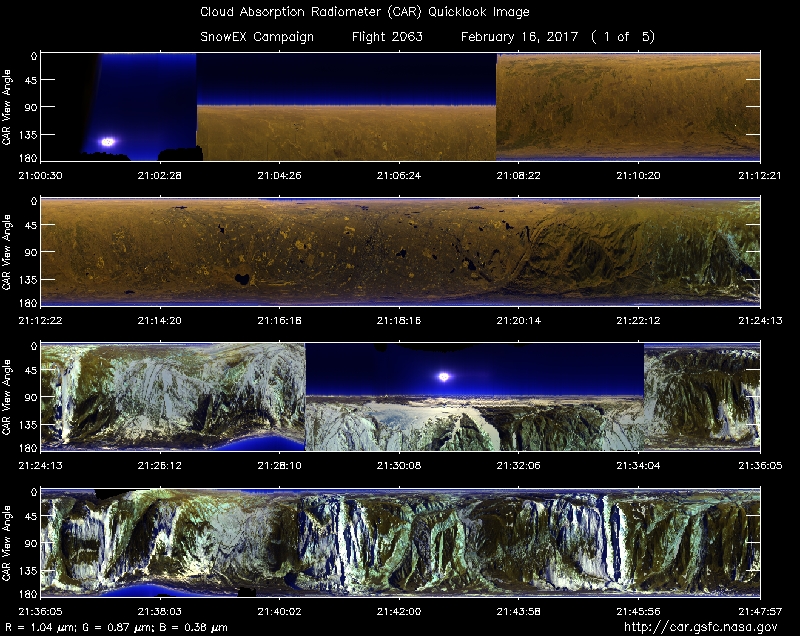
• Cloud Absorption Radiometer (CAR from NASA/GSFC) for Bidirectional Reflectance Function (BRDF) measurements
• SnowSAR (Snow Synthetic Aperture radar) - a dual frequency (X- and Ku-band) from MetaSensing, Netherlands - Radar (volume scattering).
• Quantum Well Infrared Photodetector (QWIP) infrared imaging camera system from NASA/GSFC - records IR images of target sources in the 8-10 µm band.
• Thermal infrared non-imager from U. Washington, Seattle. Has IR sensitivity in the 8-14 µm range.
• Video camera from GSFC
Approximate time in UTC (Colorado, -7 hours). Activities during CAR flight 2063 on February 16, 2017 out of Peterson Air Force Base (AFB) Airport. Observations by CAR operator/PI, Charles Gatebe, accompanied by Rajesh Poudyal, instrument operator/programmer and Kurt Rush, CAR engineer.
19:14: Power the CAR systems.
19:15: Computers power on.
19:16: motor power on. CANS system on.
19:18: CANS working well. Tested the system by pointing the CAR instrument in different directions.
19:23: CAR working fine. Finished checking instrument status.
20:20: briefing finalized.
20:27: still waiting for final flight clearance.
20:37: aircraft engines start.
20:50: taxing.
20:58: take off.
21:00: CAR instrument power on.
21:01: CAR door opened.
21:02: cryopump power on.
21:04: Ch9 detector cooling in progress.
21:06: Ch9=1.6 micron.
21:08: downward imaging mode.
21:09: Ch9 detector now stable.
21:10: very clear sky - no clouds.
21:14: testing all the filter wheel channels.
21:17: very clear sky.
21:18: approaching Fraser forest area.
21:21: close to Fraser forest. Lots of snow.
21:22: snow on trees visible.
21:24: Changed filter wheels channel.
21:25: filter wheel in automatic mode.
21:27: filter wheel - suspicious of a problem. Investigate on the ground.
21:28: starboard imaging mode.
21:32: very clear sky.
21:33: Fraser forest line.
21:34: Downward imaging mode.
21:37: finished Fraser, heading to Grand Mesa.
21:38: spike in the data for the filter wheel channel. No channels seem to saturate.
21:39: Alt. 4892 m. Auto roll correction off.
21:40: very clear sky.
21:43: Comparing two filter wheel channels: 2.1 µm vs 2.2 µm. Both look relatively dark.
21:45: Snow increasing. Higher counts recorded.
21:49: very clear sky.
21:51: 1.6 µm channel reading relatively higher than either 2.1 µm or 2.2 µm.
21:54: descending down from 4892 m.
21:56: approaching Grand Mesa exclusion box.
21:59: starboard imaging mode.
22:00: filter wheel channel - spike in the data seen.
22:01: fans on.
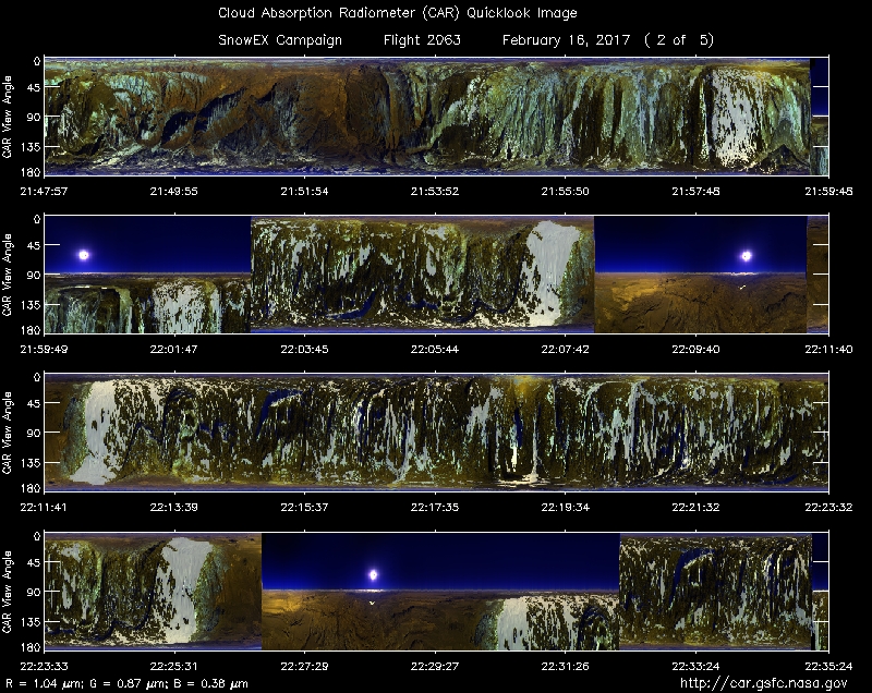
22:03: start of AESMIR (Airborne Earth Science Microwave Imaging Radiometer) lines. CAR in imaging mode. Alt. 1000 feet agl. Clear sky above.
22:09: filter wheel signal spike noted.
22:10: change filter wheel channel from 1.6 µm to 2.1 µm.
22:11: start AESMIR line B.
22:16: going down to a lower level. Alt. 12300 feet msl.
22:21: start of another AESMIR line. CAR in downward imaging mode.
22:23: very clear sky.
22:27: spikes associated with 1.6 µm. Switched the channel to 2.1 µm. Lines seem to disappear.
22:31: Filter wheel channel at 2.2 µm. In starboard imaging mode.
22:34: finished AESMIR lines.
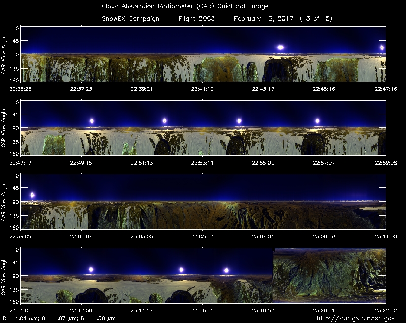
20:38: very dark over the forested areas.
20:39: setting up for BRDF circles.
20:47: start BRDF circles.
20:50: back scattering direction - snow is anisotropic.
22:52: sun direction.
22:57: coming to the end of CAR circles.
23:00: going to CAR BRDF site 2.
23:02: going up to 17,500 feets msl.
23:03: cloud deck on the left hand horizon.
23:07: approaching BRDF site location - higher altitude= 5354 m msl (600 feet agl).
23:11: start of BRDF circles.
23:14: CAR circles in progress. Clouds seen towards the horizon.
23:17: end of CAR circles.
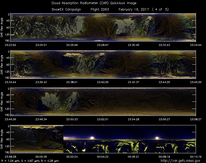
23:19: imaging mode.
23:21: setting up for SnowSAR lines.
23:23: spikes in the filter wheel.
23:24: start of SnowSAR lines.
23:26: flying in the sun direction. Shadow behind the plane.
23:27: clear sky.
23:30: over snow - no trees.
23:34: start of SnowSAR line B.
23:36: filter wheel channels looks shaky.
23:37: CAR fans on.
23:43: start of a another SnowSAR line.
23:47: heading to Senator Beck Basin.
23:48: sky very clear. Snow peak near nadir.
23:49: Alt. 5454 m (msl).
23:53: on the way to Senator Beck Basin. Clear sky.
23:58: over trees snow mix. Low sun angle. Longer shadows.
00:03: over Senator Beck basin.
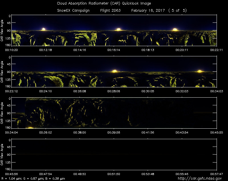
00:04: BRDF circles start.
00:05: cloud on the horizon.
00:08: Alt. 5462 m (msl).
00:10: clouds toward the horizon.
00:12: 3rd BRDF circle.
00:17: finished BRDF at 5462 m. Going to a higher level.
00:22: Ch3 (0.47 µm) higher counts seen over Senator Beck basin.
00:23: climbing to a higher level.
00:25: filter wheel channel changed from 1.6 µm to 2.2 µm. Alt.= 6401 m (msl).
00:26: BRDF circles start. Alt. 6389 m (msl).
00:28: clear sky above. Ch 2(0.380 µm) counts are high at this level.
00:30: peak in reflectance over mountain top - facing the sun.
00:33: end of BRDF circles.
00:35: downward imaging mode. Clouds toward the horizon.
00:42: low sun associated with low signal. Imaging mode. Ch 2 (0.380 µm) noisier.
00:43: haze visible towards the horizon.
00:44: starboard imaging mode.
00:45: lots of haze. Flight level : 6550 m (msl).
00:46: filter wheel in automatic mode.
00:50: Ch 1, 2, 7 looks noisy due to low light level.
00:56: Closed CAR door.
00:57: CAR door fully closed.
00:58: CAR power off, crypump off.
00:59: descending to Colorado Springs.
01:09: Approx 5 minutes to landing.
01:19: landed.
01:27: stop taxing.
01:28: engines power off. CAR parked.
01:29: CANS power off.